Model Update for Tuesday's Significant Winter Storm
Posted 03:37 AM 02/13/2024

Model Update for Tuesday's Significant Winter Storm

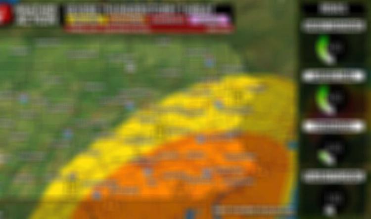
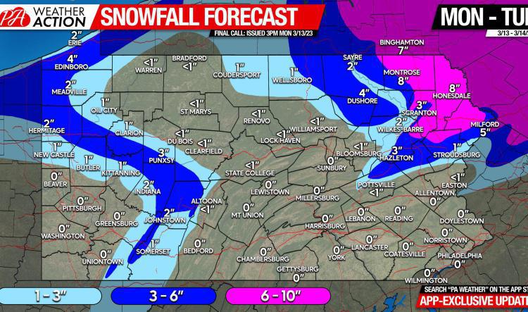
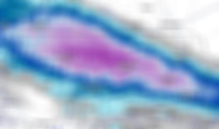
Models have had one of their worst performances in years with this one. First starting almost where we are now, then trending well north. You saw it in our first look and first call, even our second call. But ever since the Sunday morning runs, there has been an undeniable southward shift.

Model Update for Friday’s Snow Event
Posted 01:37 PM 01/18/2024

Model Update for Friday’s Snow Event

Hello everyone. Id like to apologize for the lack of model updates recently. I was trying to decide what to do with the model updates on the website and here and how they work together and we ultimately decided to stick to the app and discontinue the website paid subscription.

Significant Winter Storm Remains Likely for Weekend, Tracking Heaviest Snow Area & Rain/Snow Line
Posted 11:18 PM 01/02/2024

Significant Winter Storm Remains Likely for Weekend, Tracking Heaviest Snow Area & Rain/Snow Line

Over the last 24 hours since our last update, models have had some shifts as expected. Most notably, the axis of heaviest snowfall accumulation has shifted northwest. Also, there has been a uniform trend towards a somewhat weaker system with a lower maximum snowfall potential. This time on Monday, it appeared maximum accumulations may be 10-15”, however now that’s been reduced to 6-10”. Nonetheless, still a significant storm. We remain 100 hours out, so plenty of time for further trends which may not be good news for those looking for a heavy snowfall in Southeast PA. Starting with the European model, which has most significantly reduced accumulations the last few runs due to weaker precipitation rates, albeit still projecting a long period of moderate snow. Places near the MD line and I-95 mix with rain on the latest run. Note that for timing on these models, 00z is 7pm the previous day, 06z is 1am, 12z is 7am, and 18z is 1pm. Highest accumulations are across South Central PA…

Posted 11:38 PM 01/01/2024

WATCHING SIGNIFICANT SNOWSTORM THREAT ACROSS MUCH OF PENNSYLVANIA THIS WEEKEND

It seems like just days ago the month of January had a rather poor look in terms of snowfall, as temperatures looked to be above average for the month. While we can’t say for sure what the remainder of January will bring, we can say that the chances of a significant winter storm around January 6-7 are increasing rapidly. There has been growing consistency on the models over the last two to three days regarding this significant winter storm threat. Regardless, we are still 5-6 days out and are seeing the usual deviations as different models have different high pressure placements and strengths. Beginning with the American model, the GFS. It has by far the strongest high pressure in Quebec which keeps the low pressure off the coast farther south and as a result, heaviest snowfall is in Virginia with Southern PA seeing light to moderate impacts. This solution is certainly possible but remains least probable at the moment. Below is the associated snowfall output from the GFS. The GFS…

Posted 12:29 AM 12/18/2023

Brief Model Update on Backend Snow & Precipitation Totals Now – Tuesday

A brief weekend update as rain begins to fall in parts of the state. Below is expected precipitation through Tuesday. Now onto snowfall. Here is the model blend, or average snowfall output among models. Generally above 6” in the lake effect belts of NWPA about 10 miles away from the shore, and in western facing slopes of the Laurel Highlands. Now into the other short range guidance, which isn’t as generous in the Pittsburgh area. Winter weather alerts have been issued in much of Western Pennsylvania ahead of this, and lake effect is always localized.

Posted 11:46 PM 12/07/2023

Watching Rain to Snow Changeover In Areas of PA Sunday Night into Monday AM

After snow this morning took many people by surprise (despite being well forecasted by PWA), we now turn our attention to a more complex storm for Sunday into Monday. Models have had a very rough time with this one, originally projecting a very amplified storm with blizzard conditions in the Upper Midwest and a significant severe thunderstorm risk in the Tennessee Valley. Over the last few days, models have trended towards a weaker storm that moves up I-95 Sunday into Monday. However, since there's a lack of a good high pressure to our north, many populated areas in the valleys across Pennsylvania will be wet, rather than white. Let's take a look at the latest European model's progression of the storm in Pennsylvania. Of course, as we're still four days out, there's room for change and chances are, models may trend to an even weaker solution with a later changeover and very little snowfall. Nonetheless, here is the 12z Thursday ECMWF model: Here is the European model's snowfall…

Final Call Forecast for Today's Severe Thunderstorm Threat
Posted 12:23 PM 06/26/2023

Final Call Forecast for Today's Severe Thunderstorm Threat

Moderate risk levels for wind damage, large hail, tornadoes, and flash flooding today as numerous severe thunderstorms are possible across much of Eastern PA. Have a way to receive alerts today, and keep an eye on the radar! The hourly forecast is not reliable on days like this!

Seasonable Today With Showers in NEPA, Widespread Rain Coming Monday, Totals Here ~>
Posted 12:14 PM 06/10/2023

Seasonable Today With Showers in NEPA, Widespread Rain Coming Monday, Totals Here ~>

After a surprisingly cool Friday, we're warming up today's with seasonal temperatures and mostly sunny skies. Scattered showers and storms are possible in Northeast PA and the Lehigh Valley from the late afternoon to evening. The smoke is gone for a while, but with so many fires in Quebec, there's a high chance it'll occasionally throughout the Summer.

Article: Waking Up to Worst Air Quality of Week in Many Areas, Smoke Soon Gone?
Posted 11:27 AM 06/08/2023

Article: Waking Up to Worst Air Quality of Week in Many Areas, Smoke Soon Gone?

The worst air quality this week is present this morning in much of South Central & Southeast PA (AQI 300-500). Fortunately, the plume of thick smoke causing this will drift south today and exit the area by the afternoon. We won't see an immediate sizable improvement in air quality though, more so a gradual change. More smaller plumes of smoke are likely this afternoon into tonight.

Final Call Snowfall Forecast for Imminent Winter Storm
Posted 08:54 PM 03/13/2023

Final Call Snowfall Forecast for Imminent Winter Storm

Few changes from our first call today. Short range models have trended northeast with the precipitation shield, aligning much closer to global models now. Our forecast yesterday ignored the 3km NAM and long range HRRR, as those models tend to struggle beyond 12-24 hours out.

Update On Early Next Week Major Coastal Storm
Posted 08:49 PM 03/10/2023

Update On Early Next Week Major Coastal Storm

A major winter storm is growing more and more likely for early next week. The problem for PA snow lovers is that it will largely miss the state. Only Northeast PA and maybe the Lehigh Valley is in the game.

Surprise Snow Coming to Narrow Strip of PA Tonight
Posted 12:13 PM 03/06/2023

Surprise Snow Coming to Narrow Strip of PA Tonight

A low pressure pushing east from the Ohio Valley will pick up some moisture as it crosses the Great Lakes and produce a heavy band of snowfall across parts of Pennsylvania tonight.

Final Update for This, More Wet Than White, Storm
Posted 04:46 PM 03/03/2023

Final Update for This, More Wet Than White, Storm

Another mostly rain event is on our doorstep. Higher elevations may briefly start as snow before switching to rain with a few sleet pellets, while the valleys will see rain start to finish. A couple hours of snow followed by sleet are expected in near Route 6, adding up to an inch or two of slush. Also, the high ridgetops above 1800' elevation will be icy tonight, so be careful if crossing one is in your itinerary.